| |
| HOME |
| About Tenaya |
| About Us |
| Latest Update |
| Logs from Current Year |
| Logs from Previous Years |
| Katie's View |
| Route Map |
| Links |
| Contact Us |
![]()
2009
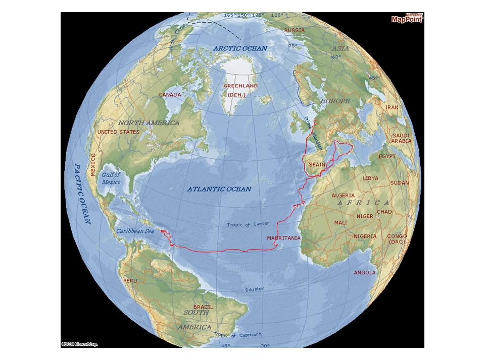
December 18, 2008 to January 3, 2009 Cape Verdes to Barbados. Distance 2650 miles. 16 days.
January 9 - 10. Bridgetown, Barbados to Admiralty Bay, Bequia, SVG. Distance 120 miles. 17 hours.
January 28 - 31. Bequia to Saline Bay, Mayreau to Tobago Cays and return to Admiralty Bay, Bequia. Distance 68 miles.
February 6. Admiralty Bay, Bequia to Wallilabou, St. Vincent. Distance 14 miles. 3 hours.
February 7. Wallilabou, St. Vincent to Soufriere, St. Lucia. Distance 43 miles. 6 3/4 hours.
February 9. Soufriere - The Pitons, St. Lucia to Rodney Bay, St. Lucia. Distance 21 miles.
February 11. Rodney Bay, St. Lucia to Fort de France, Martinique. Distance 36 miles. 5 1/2 hours.
February 12. Fort de France, Martinique to St. Pierre, Martinique. Distance 15 miles. 3 hours.
February 13. St. Pierre, Martinique to Roseau, Dominica. Distance 40 miles. 6 1/2 hours.
February 25. Roseau to Portsmouth, Dominica. Distance 19 miles. 3 1/2 hours.
February 28. Portsmouth to Pain de Sucre, Isle des Saintes. Distance 24 miles. 4 1/2 hours.
March 4. Isle des Saintes to Pigeon Island, Guadaloupe. Distance 24 miles. 4 hours.
March 5. Pigeon Island to Deshaies, guadaloupe. Distance 10 miles. 2 hours.
March 6. Deshaies, Guadaloupe to English Harbour, Antiqua. Distance 48 miles. 8 hours.
March 10. English Harbour, Antigua to St. John's Harbour, Antigua. Distance 22 miles. 5 hours.
March 11. St. John's Harbour, Antigua to Low Bay, Barbuda. Distance 44 miles. 7 hours.
March 12. Barbuda Island to Port de Gustavia, Saint Barths Island. Distance 66 miles. 13 1/2 hours.
March 17. Gustavia, Saint Barths to Ile Fourchue Marine Reserve. Distance 6 miles. 1 1/4 hours.
March 19. Ile Fourchue, Saint Barth to Marigot Bay, Saint Martin. Distance 23 miles. 3 1/2 hours.
March 21. Marigot Bay, St. Martin to Simpson Bay, St. MArtin. Distance 10 miles. 2 hours.
March 22. Simpson Bay, St. Martin to Virgin Gorda Marina, British Virgin Islands. Distance 91 miles. 17 hours.
March 28. Virgin Gorda Marina to Little Harbor, Peter Island. Distance 16 miles. 3 hours.
March 30. Little Harbor, Peter Island to Banures Bay, Norman Island. Distance 5 miles.
March 31. Benures Bay, Norman Island to The Caves, Norman Island to Soper's Hole, Tortola. Distance 11 miles.
April 27. Soper's Hole to Little Harbor, Peter Island.
May 1. North Sound Virgin Gorda
May 23. Peter Island, Norman Island, Tortola, British Virgin Islands
June 2009 until November 2009 Tenaya will be stored on the hard in the British Virgin Islands.
From May 2008 until September 2008 we cruised the Western Mediterranean covering 3400 miles.
We sailed full time from May 2008 (Almerimar, Spain) until June 2009 (British Virgin Islands covering 9265 miles.
Tenaya has now traveled 12,725 miles since April, 2006.
November 28 Tenaya back in the water
December 1 British Virgin Islands to St. Maarten. Distance 118 miles. 26 hours.
December 16 St. Maarten to Saba. Distance 36 miles. 5 1/2 hours.
December 19 Ladder Bay, Saba to Basseterre, St. Kitts. Distance 56 miles. 9 hours.
December 20 Basseterre, St. Kitts to Pinney Beach, Charlestown, Nevis. Distance 13 miles. 2 1/4 hours.
December 21 Nevis to Basse-Terre, Guadeloupe. Distance 107 miles. 25 hours.
December 24 Basse-Terre, Guadaloupe to Isle des Saintes. Distance 21 miles. 3 hours.
Tenaya sailed a total of 1519 miles in 2009.
Note: Distances are the Nautical Miles recorded by Tenaya's Log. The shortest route distance from a map may be different either because of the effects of a tidal stream or our requirement to tack back and forth
Other Maps:
Marina Costs:
![]()
"What lies behind us and lies before us are small matters compared to what lies within us."
Ralph Waldo Emerson
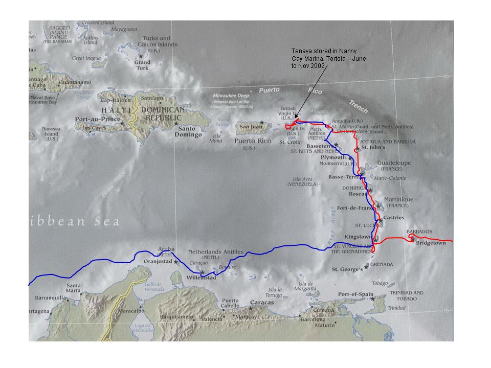
Red route December 2008 to June 2009 Blue route December 2009 to 2010